Mount Rwenzori is the 3rd highest mountain just after Mount Kilimanjaro and Mt Kenya. Several mount climbers find it challenging to hike it to the summit however from the many reviews we get from them, all say that the mountain offers excellent views and scenery than the two highest peaks in Africa.
Mountain hiking is the major activity due to the presence of Mountain Ruwenzori. On this activity, the tourists take about seven days and six nights to get to the highest peak on Mountain Rwenzori known as Margherita.
Gorilla trekking is one of the most fascinating wildlife experiences. This much sought out activity by primate lovers is only possible in four national parks, Bwindi National Park in Uganda, Virunga National Park in DR Congo, Volcanoes National Park in Rwanda and Mgahinga Gorilla Park in Uganda. Uganda is special because she hosts half of the remaining population of mountain gorillas in two national parks, Bwindi and Mgahinga.
Bwindi Impenetrable National Park
Bwindi Impenetrable Forest is a UNESCO world Heritage site since 1994 because of its great biodiversity. Apart from mountain gorillas, Bwindi currently has 120 species of mammals which include small Antelopes, Giant Forest pigs, the African Golden Cat, the side-striped Jackal and African Civet. You can find several primates in the park including Chimpanzees, L’Hoest’s Monkeys and Black/White Colobus Monkeys.
Bwindi Impenetrable Forest has four sectors where visitors can do gorilla tracking Rushaga, Nkuringo, Ruhija and Buhoma. It is therefore possible to do double gorilla tracking in Bwindi unlike in Mgahinga. Visitors can track gorillas in one section and then another section the next day. Watching gorillas twice makes it possible to compare experiences tracking different gorilla families and in different sections of Bwindi.
Buhoma sector: Situated in the northern side of Bwindi Impenetrable Forest National Park, Buhoma region is exceptionally one of the four most incredible tracking regions that you shouldn’t miss to track while on mountain gorilla adventures in Uganda. This region features as most famous as the oldest trailhead in Uganda given when it comes to mountain gorilla adventures.
Rushaga Sector: Located in the southern part of the park. This sector has the highest number of habituated gorilla families. It is one of the sectors where habituation is currently taking place. It is easily accessible to travelers coming from Kigali through the Cyanika border in Kisoro which is approximately a 3hr drive. Rushaga sector inhabits the highest population of habituated gorilla families as compared to other sectors in Bwindi impenetrable national park because other sectors offer 4 gorilla families while Rushaga sector has 8 gorilla families. Therefore, visitors interested in gorilla trekking in Rushaga sector have a chance of choosing any gorilla family they prefer to visit.
Nkuringo Sector: It is situated in the southern region of the park. Nkuringo is home to 3 fully habituated gorilla families. The sector is well known for its views of Mount Nyiragongo and Mount Nyamuragira. One of the hardest sectors to trek in because of the terrain but has one of the best views. The sector has high altitudes. Other than that, the sector can easily be accessed from Kabale District which is 45km to Kisoro on a 3hr drive on the Kabale-Kisoro highway.
Ruhija Sector: Situated on the Eastern part of the park. It is suitable for those travelers who have Queen Elizabeth National Park as part of their itineraries using the Ishasha sector. It is home to 4 habituated gorilla families. Out of the 4 sectors, it’s one of the coldest. Other than gorillas the park also has elephants and monkeys. Some of the activities carried out in this sector include cycling/mountain biking, birding cultural encounters of the Batwa community, and nature walks. Ruhija is also the only sector in the park where elephants are present. Other animals include monkeys and antelopes.
Mgahinga National Park
The less known Mgahinga Gorilla National Park is part of the wider Virunga conservation region that also includes the Volcanoes Park in Rwanda and the Virunga National Park in the Democratic Republic of Congo. The park is located on the south-western corner of Uganda in the town of Kisoro. Mgahinga was upgraded from a game reserve into a full national park in 1991 mainly to protect the mountain gorillas that were in frequent conflicts with humans living within and outside the park. Mgahinga is the smallest national park in Uganda and covers an area of 34 square kilometers. The park gets its name from a Kinyarwanda word “Gahinga” referring to the small lava stones common in gardens at the foot of the mountain.
Mgahinga National Park has a total population of 80 mountain gorillas, but only one gorilla group is habituated and open to tourists, the Nyakagezi family. The group used to move to Rwanda and Congo but have now settled in Uganda for more than three years. Gorilla safaris to Mgahinga are great because the park attracts fewer crowds. Having one habituated gorilla group means only 8 gorilla permits can be sold in a day. Visitors are advised to book their permits weeks in advance from the Uganda Wildlife Authority offices in Kampala or the Park Headquarters in Ntebeko.
Gorilla trekking Mgahinga starts at 8 am with briefing. After the briefing, visitors are led by the park rangers to find the group. Gorillas Tracking in Mgahinga National Park While tracking the gorillas expect to encounter pristine forest, primates, birds and other forest creatures. The time taken tracking the gorillas will depend on the location of the group that day and can take anywhere between 2 to 3 hours. Go prepared with a good camera to capture one of the most amazing wildlife experiences. Will you see the primates? Well, the chance of seeing mountain gorillas is pretty high.
Rwenzori Mountains
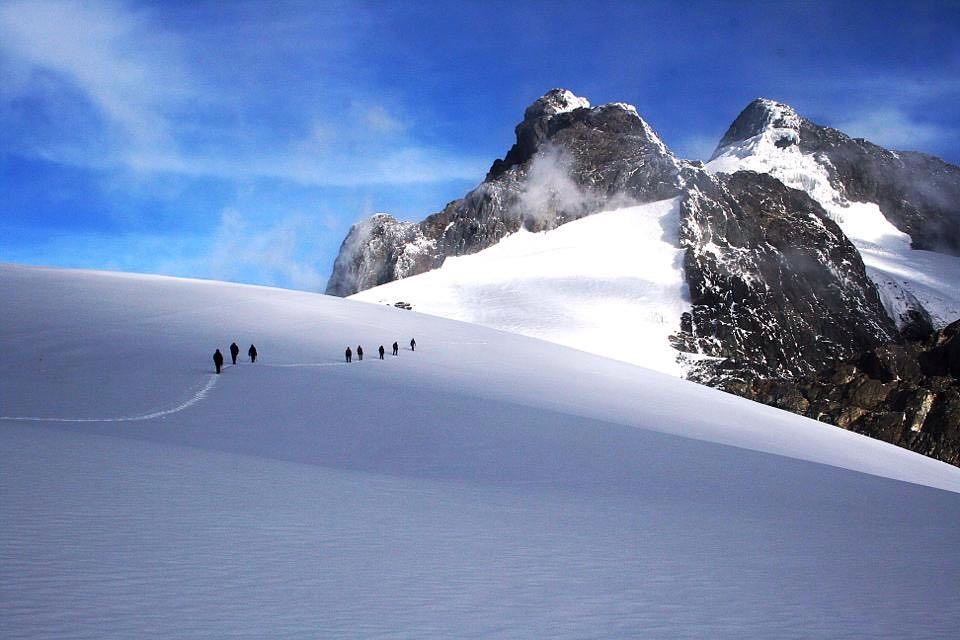
Rwenzori Mountain was declared as a UNESCO World Heritage Site in Uganda and located in western Uganda, forming a natural boundary between Uganda and the DR Congo. The highest peak of Ruwenzori is Margherita, rising 5109m above sea level and it has glaciers throughout the year yet Rwenzori is crossed by the Equator
Located in western Uganda, the Rwenzori mountains national park gets its name from the Mount Rwenzori that is also known as mountains of the moon. Mountain Rwenzori is the highest mountain in Uganda and the third highest mountain in Africa. The mountain has several Glaciers, waterfalls, and lakes. This national park is located in south western Uganda on the east side of the western African rift valley in Bundibugyo District.
It is a block mountain resulting from the formation of the Rift Valley. The Rwenzori Mountains is the highest mountain range in Africa, with six glacial peaks: Mount Stanley, Mount Speke, Mount Emin Pasha, Mount Gessi, Mount Luigi da Savoia and Mount Baker which has made Mountain trekking tour and safaris to Uganda an Unforgettable Experience to the entire World’s Mountain Hikers.
NYAKALENGIJA TO NYABITABA HUT, 2.652M
From the Rwenzori Mountains National Park Head Quarter at Nyakalengija, 1.646 m., you will receive the briefing from the guides, with the possibility of hiring equipment. The hike starts through the plantations and homes of the Bakonjo, the people of the mountain, gradually reaching garden plots and elephants grass. You follow the Mobuku River, until crossing the Mahoma River. The trail passes through an open bracken fern slopes and Podorcarpus Forest, up to Nyabitaba Hut, 2.652 m., which is the arrival point for the day. This will take from 5 to 6 hours. From the location, you are facing on the North the Portal Peaks, 4.627 m. and in front Mount Kyniangoma. During the day, you might see monkeys, the Rwenzori Turaco and hearing the chimpanzees.
NYABITABA HUT TO JOHN MATTE HUT, 3.414M
From Nyabitaba Hut you cross the Kurt Shaffer Bridge, through a muddy area along the Mubuku River. Then the trail climbs up through the bamboo forest. You reach a steep rocky area, which leads to Nyamuleju Hut. This point marks the start of the giant lobelia and groundsel zone. The way proceeds through a bog full of typical plants along the Bujuku River. The final point is John Matte Hut, 3.414 m. for spending the night. From Nyabitaba Hut to John Matte it can take approximately 6 hours. Enjoy the view of Mount Stanley and snowcapped Margherita and Elena Peaks.
JOHN MATTE HUT TO BUJUKU HUT, 3.962M
From John Matte Hut you cross the Bujuku River and enter the lower Bigo bog, a grassy bog where you experience how to jump from tussock to tussock. You reach Bigo Hut and enter the upper Bigo bog, proceeding to Lake Bujuku, where it is starting the alpine savannah zone of little vegetation. You finally arrive at Bujuku Hut, 3.962 m. This day hike can take up to 5 hours. There you have a view on the peaks of Mount Stanley, Mount Baker and Mount Speke.
BUJUKU HUT TO ELENA HUT, 4.540M
From Bujuku Hut you climb through moss draped groundsel vegetation, to Scott Elliot Pass, 4.372 m., between Mt. Baker and Stanley. Here you divert to Elena Hut, 4.540 m. for spending the night before climbing Mt. Stanley.
ELENA HUT TO KITANDARA HUT, 4.023M
From Elena Hut you ascend the last tract of rock and ice which leads to Margherita Peak on Mt. Stanley, 5.109 m. Time to complete the climbing about 3 hours. The peak was first climbed by the Duke of Abruzzi at 9.30am on 18th June 1.906. After you descend to Upper Kitandara lake and through thick mud to Lower Kitandara lake where is located Kitandara Hut, 4.023 m where you will spend the night. Time to complete the hike about 3 hours more. From Kitandara Hut you can proceed for climbing Mount Baker or Mount Luigi di Savoia and the peak Vittorio Sella. Enjoy the view of Mt. Luigi di Savoia.
KITANDARA HUT TO GUY YEOMAN HUT, 3.261M
From Lake Kitandara you climb to Fresh field Pass, 4.282 m., a long flat of high alpine mossy glades, before descending the circuit among rocky and boggy areas. The panorama is dominated by the glaciers of Mounts Stanley and Baker and Mount of Savoy. A muddy trail leads to Akendahi, Bujongolo and Kabamba rock shelters, where starts the Kabamba valley down to Guy Yeoman Hut, 3.261 m. This can take up to 6 hours. The hut is surrounded by a beautiful landscape of mountains, vegetation and rivers.
GUY YEOMAN HUT BACK TO NYAKALENGIJA
Final descent back to Nyakalengija. The trial is attractive along the valley of the Mobuku and Kichuchu rivers, rich in plants and flowers of the heather zone before reaching the bamboo forest. See Kabamba falls on the way. Time to reach Nyabitaba Hut is about 4 hours. From Nyabitaba starts the 40 minutes trial to see Lake Mahoma and back to the hut for descending to the Park Head Quarter. The trial takes more 2 to 3 hours. At the finishing point your safari guides meets you.
When to visit the Rwenzori
It is possible to trek in the Rwenzoris all year round. At all times of year you should be prepared for a combination of sun, rain, mud, fog, ice and snow. However, the period from late June to early September and again late December to the end of February does tend to have lower rainfall, which means visitor numbers do peak during this time.
It is also worth remembering that the wetter months mean more rain lower down the slopes, but more snow at higher altitude, enhancing the already mystical experience of trekking in the Rwenzoris.
Conclusion
You will be able to see a variety of Gorillas in Bwindi and Mgahinga National Park once you book combined 12 days gorillas & Rwenzori trekking. Animals will be seen especially on the foothills of the mountain. However, this hike is not an easy expedition, therefore you must be healthy and physically able to take on this challenge.